 Cripps Corner in East Sussex lies about 4 miles north east of Battle ,
on an the site of an old Roman garrison, which was used
to guard and control the road connecting Whatling Street
(Rochester) to the ports at Bodiam , Sedlescombe and
Westfield . Cripps Corner in East Sussex lies about 4 miles north east of Battle ,
on an the site of an old Roman garrison, which was used
to guard and control the road connecting Whatling Street
(Rochester) to the ports at Bodiam , Sedlescombe and
Westfield .
The area was used for iron production by the Romans , and
nearby are many bloomeries(iron smelters), which sent
the iron ingots(blooms) to the local ports for shipping to
Londinium.
After the Norman conquest the land was given to the Count
of Eu, and was included in the Hundred of Staple (see
Staplecross ). The land was gifted to Robertsbridge Abbey
in the 12th century by Alicia, widow of the 4th Count of Eu.
The Abbot of Robertsbridge Abbey in 1332 was Walter Krips,
and it believed that Cripps Corner is derived from his name.
Cripps Corner was also the site of the Gallowes of Whoorne,
which was still in use for execution of smugglers and
highwaymen until the 17th century.
In the early part of the 20th century, a wheelwright
named Tedham lived here. He was also the village
undertaker, however his speciality was the manufacture
of the big Sussex Farm Wagons. One of them - with his
trade plate on it may be seen at Michelham Priory.
In September 1941, the Ticehurst Home Guard were on
manoeuvers in the Cripps Corner area, with the local
pub the White Hart as their target. After disembarking
from Warrens Coach, in a wooded area, they marched
south and eventually crept through the hedges and
ditches up to the road in front of the pub. Here they
let off a volley at the army defenders - much to their
surprise - as the operation was supposed to have
finished an hour earlier! The story ends on a high
note as the publican opened the bar to allow the
gallant Home Guard to quench their thirst.
(We
are grateful to the landlord of the White Hart for
providing some of this information) | 

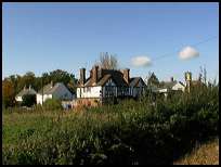
 Cripps Corner in East Sussex has some nice South facing views, which
can be seen from the vicinity of the Public House.
Cripps Corner in East Sussex has some nice South facing views, which
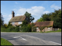
can be seen from the vicinity of the Public House.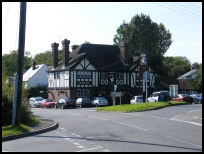 Cripps Corner in East Sussex has a small number of businesses.


